How to get USGS topographic maps at no cost
By Steve McCollum; posted October 11, 2009
View Original: Click to zoom, then click to magnify (1400 x 1050) 692KB

|
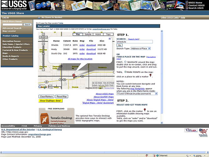
Navigate to http://www.usgs.gov. Click on the "Maps, Imagery, and Publications" tab to go to that page. Looking under Maps, click on "Download digital scans of topo maps". On "The USGS Store" page, look on the right side under "Topo Maps", click on "Download Topo Maps Free". This takes you to the Map Locator. On the Map Locator, type in the name of the location you're interested in, then click "Go". Usually entering cityname, state will do. This user interface is a little strange until you get used to it. It can be either in Navigate or Mark Points mode. You select the mode by two radio buttons at the right side of the page. In Navigate mode, you can drag the map around, and can zoom by double-clicking. In Mark Points mode, you can drop a Google-style marker. Then, by clicking on a marker, you can see what maps are available. Try Shields, KS for example. When you click Go, you'll see a push pin marker at Shields. The name of the map is also Shields. This isn't always the case. If you click on that marker, a balloon pops up to show you what maps are available (see picture above and footnotes below). You can download them from here. They come down as .zip files. You will need WinZip or a similar utility to decompress them. After decompressing you will get a .pdf file of the scanned map. Of course, you view this with Adobe Reader. I also downloaded and installed the TerraGo toolbar for Adobe Reader. It's available at the bottom of the page where you selected your maps to download. It makes map viewing more convenient. Footnotes: The 7.5 x 7.5 maps are the most detailed. They cover a rectangle 7.5 x 7.5 minutes. A minute is 1/60th of a degree, so 7.5 minutes is 1/8th of a degree. At the equator, a degree of longitude is about 70 miles. It's less at higher latitudes, of course. In North America, you can figure that a 7.5 minute map covers about 6 to 7 miles of longitude. The 30 x 60 maps cover a rectangle 30 x 60 minutes, or about 24 x 48 miles, depending on the latitude. And the 1 x 2 maps cover 1 x 2 degrees. Not all locations are covered by fine scale maps. Beware: some of the newer maps show elevations in (ugh) Meters, not feet. Crass editorial comment: I pay taxes in Dollars, not Euros; plane surveying and land deeds are recorded in feet, rods, and miles, not meters. Enough said. Managing map files: in Windows XP, I created a folder My Maps under My Documents. I put it there because that makes the maps conform to a backup strategy that includes everything in My Documents. In the My Maps folder, I have a folder named USGS for both the downloaded zip files, plus the uncompressed PDF files. I delete the zip files after uncompressing them. I also have other folders in My Maps for Mappoint, QSTARZ GPS, etc. Honestly, I don't know why USGS bothers to ZIP the PDFs. Maybe it is in deference to users with slow connections. Since Adobe already provides some compression to PDFs, the additional step of ZIPping the file only gains 10% or so. It hardly seems worth the bother. |